Tag Archives: Roads

Moron Drivers stay off Otago Southland roads….

….this long Easter Weekend.

[ends]

****

The warm fuzzy more genial (guinea pig?!) message:

At Facebook:

****

At Facebook:

Fri, 14 Apr 2017
ODT: On the buses over Easter weekend
Heritage buses will be back on the road over Easter weekend, providing public transport over the public holiday. Otago Heritage Bus Society treasurer/secretary Jacqui Hellyer said Dunedinites could ride the buses, which serviced St Kilda, St Clair, the Octagon, Brockville, Halfway Bush and Normanby, for a gold coin donation on Good Friday and Easter Sunday.
The services would run hourly and the timetable would be available on the Otago Heritage Bus Society’s Facebook page, Ms Hellyer said. Passengers could take service dogs or pet dogs on a leash.
The St Kilda service had stayed like its former route – to Brockville then Halfway Bush – and the other services took the routes used on non-public holidays, she said.

The Otago Regional Council, in a statement published on its website, said there would be no bus services on Good Friday or Easter Sunday. However, the standard Saturday timetable would apply on Saturday, and Easter Monday would run on the public holiday timetable. Normal services would resume on Tuesday.

****

Cool image at Twitter:

Posted by Elizabeth Kerr

This post is offered in the NZ public and foreign interest.

Leave a comment

Filed under Democracy, Education, Fire and Emergency NZ, Geography, Health & Safety, Hospital, New Zealand, People, Police, Public interest, Tourism, Transportation, Travesty

Dunedin and the Accessible Journey —it’s hard work! #fixit

An uplifting educational element to election campaign pressures, an event involving the public too – Great going guys!

Channel 39 Published on Oct 4, 2016

### channel39.co.nz Wed, 5 Oct 2016
Mayor hopefuls tackle wheelchair challenge
Disability access is on the minds of some of Dunedin’s mayoral candidates. They’ve been participating in a wheelchair challenge orchestrated by a city council candidate with cerebral palsy. And it’s raised questions about the city’s accessibility.
Ch39 Link

****

### ODT Online Thu, 6 Oct 2016
Wheelchair experience enlightening
Dunedin mayoral candidates got to experience life in a wheelchair yesterday, and immediately discovered difficult cambers, bus limitations and the problem of negotiating crowds. Jim O’Malley, Cr Andrew Whiley, Barry Timmings and Abe Gray joined council candidate Joshua Perry on a challenge to take a wheelchair two blocks down George St and back, a mission that proved harder than it sounded. The challenge was organised by Mr Perry, who uses a wheelchair.
Read more

Published by Elizabeth Kerr

Election Year. This post is offered in the public interest.

4 Comments

Filed under Coolness, DCC, Democracy, Design, District Plan, Dunedin, Economics, Events, Finance, Geography, Health, Infrastructure, Inspiration, Media, New Zealand, People, Politics, Proposed 2GP, Public interest, Resource management, Tourism, Town planning, Transportation, Urban design

Johnstone on ORC report : ‘The Natural Hazards of South Dunedin’ (July 2016)

The Natural Hazards of South Dunedin – July 2016 [read online]
Otago Regional Council
ISBN: 978-0-908324-35-4
Report writers:
Michael Goldsmith, ORC Natural Hazards Manager
Sharon Hornblow, ORC Natural Hazards Analyst
Reviewed by: Gavin Palmer, ORC Director Engineering, Hazards and Science
External review by: David Barrell, Simon Cox, GNS Science, Dunedin

Received from Neil Johnstone
Sun, 29 Aug 2016 at 8:17 p.m.

Message: Misinformation on the causes of the June 2015 South Dunedin flood have abounded since the event. As if the victimised residents haven’t suffered enough from others’ inactions (before and during the event), they are now being subjected to a hazards discovery process whose vigour appears to be exceeded only by its own recklessness. Following are a commentary of the hazards approach adopted by the Otago Regional Council (ORC), and a summary of my investigations into the flood event that I commenced after the publication of Dunedin City Council’s first flood report back in November 2015.

You can download Neil Johnstone’s report or read it below (formatted slightly differently to suit the WordPress template).

█ Download: A REVIEW OF ORC REPORT THE NATURAL HAZARDS OF SOUTH DUNEDIN (1) (PDF, 587 KB)

AN APPRAISAL OF RECENT REPORTING OF SOUTH DUNEDIN HAZARDS

N.P JOHNSTONE, BEng (Civil), MIPENZ

1. Introduction

There is some irony that DCC and ORC should be planning “drop in” sessions for residents in respect of South Dunedin hazard issues during September 2016, some 15 months after the major flood. The prime cause of flooding in June 2015 was DCC’s failure to maintain its infrastructure (not just mudtanks), and its failure to operate its pump stations to their intended capacities. The subsequent spread of misconceptions (i.e. groundwater levels, rainfall significance etc) surrounding the flood causes was at least partly due to inaccurate ORC analyses and reporting.

Repetitive and new doubtful information emanating from ORC via its latest report has been noted. Presentations and an over-simplistic video production have been observed. A footnote covering these observations is included at the end of this appraisal.

Long-delayed DCC reports on causes of the South Dunedin flooding have already been strongly criticised by the author. Specifically discredited are misrepresentations of sea level, groundwater and rainfall ranking. Accepted now by DCC as factors (somewhat grudgingly, and depending on the audience) are mudtank blockage and Portobello Road pump station failures (plural); still to be fully acknowledged are the failures at Musselburgh Pumping Station.

Attention is now turned to significant parts of hazard reports produced by the Otago Regional Council and utilised by DCC.

2. Coastal Otago Flood Event 3 June 2015 (ORC, published October 2015)

This report deals with a wider area than South Dunedin. It is apparent that ORC staff never visited the flooding areas of South Dunedin on 3 June, but took advantage of fine weather to take some water level readings the following day. The opportunity for useful progressive surface water level recording was thus lost. Levels were collected at some 150 points on 4 June. ORC’s main conclusion was that “localised variations in topography were probably the main driver of flood depth”. Or, put another way, water depth was deepest where the ground was lowest. This seems hardly surprising, and even trivial. No attempt was made to explain the photographic images presented of extensive ponding remaining well after the rains had ceased. The phenomena of blocked mudtanks and unutilised pumping capacity went seemingly unnoticed.

The report does usefully reference ORC’s four borehole recorders of groundwater, but makes the somewhat misleading assessment that groundwater levels were “elevated” prior to the rainstorm. This misinformation was seized upon by agencies such as DCC and the Office of the Parliamentary Commissioner for the Environment to highlight climate change impacts.

Having obtained the actual groundwater level data from ORC via the LGOIMA process, the author was able to reveal this “groundwater fallacy” in reviews from February 2016, but it was not until the publication of NZ Listener’s article (June 11-17, 2016) entitled ‘FLOOD FIASCO’ that ORC admitted that pre-flood groundwater levels were in fact “just a little bit above average”. ORC now seems intent on resurrecting this fallacy.

The ORC report fails to address the real and key issues of pumping station failures (Portobello Road and Musselburgh), or comparisons with much lesser flood impacts in the larger rainfall event of March 8/9 1968.

The report states that the 2015 24-hour rainfall was the largest since 1923. This was patently incorrect, but again was utilised by DCC to divert blame from their role in the disaster.

3. The Natural Hazards of South Dunedin (ORC, published July 2016)

The report states unambiguously in its Opening Summary that the major flooding of June 2015 was “a result of heavy rainfall, surface runoff, and a corresponding rise in groundwater”. By now, most people are aware that the causes of the flooding’s disastrous impact were failure to optimally operate pumping stations, failure to clear mudtanks, and failure to deploy staff to key areas during the event. Again, none of these factors is addressed in ORC’s report.

The report presents a table on its second page entitled “Factors Which Can Influence Flood Hazard”. Examples of exaggerated negativity include:

1. Heavy Rainfall:
– Many recorded instances of rainfall leading to surface flooding.
– Heavy rainfall events have occurred frequently over the last decade.

Comment: These conclusions do not appear to be supported by the report’s text, and are vague, factually challengeable and alarmist. Prior to 2015, no major flooding had occurred in South Dunedin since 1968, and even that was minor by comparison.

2. Sea Level:
– Groundwater level fluctuates (by up to 0.5m near the coast) on a twice-daily cycle in response to normal ocean tides.

Comment: All of South Dunedin is near the coast; most of the area does not experience such large fluctuations. This should have been made clear by the inclusion of groundwater data from all 4 ORC sites across the plain, not just from Kennedy Street.

3. Seismic:
– Large earthquakes could result in increased flood hazard on the South Dunedin plain, due to liquefaction-related land subsidence or direct, sudden, changes in land elevation relative to sea level.

Comment: All areas of NZ have some susceptibility to earthquake damage. Dunedin is amongst the areas at lowest risk; no incidences of even minor liquefaction have ever been reported in South Dunedin, and little or no clearly liquefiable materials have been identified (Refer GNS, 2014*). Continue reading

27 Comments

Filed under Baloney, Business, Climate change, DCC, Democracy, District Plan, Dunedin, Economics, Finance, Geography, Health, Heritage, Housing, Infrastructure, Name, New Zealand, OAG, Ombudsman, People, Politics, Project management, Property, Proposed 2GP, Public interest, Resource management, Site, South Dunedin, Town planning, Transportation, Travesty, Urban design, What stadium

South Dunedin Action Group: Notes of meeting with DCC (3 May 2016)

Received.
Friday, 6 May 2016 6:02 p.m.

From: Clare Curran [Dunedin South MP]
Subject: Notes from the Meeting with DCC on 3 May
Date: Fri, 6 May 2016 00:31:05 +0000
To:

Dear everyone
Further to my last email here is the notes taken by office from the meeting with the Mayor and senior Council management on 3 May.
This is to keep you informed and for transparency purposes.

A new meeting date will be set up soon and I will keep you all informed

Kind regards

Clare Curran

[begins]

Notes from meeting 3 May 2016
South Dunedin Action Group (SDAG) and mayor + senior management

Mayor Cull
– acknowledged that there was collective concern, that they were pleased to meet with the group and that the meeting provided the best place to provide clarifications
– Acknowledged that the process had been lengthy and frustrating, and “sloppy”
– Council was now very sceptical about evidence relating to the flood and had been let down. He added that they would not make any changes to anything without evidence.
– If the event occurred again even with the proper maintenance there would have been severe flooding
– Determined to make the system we have work the best that it can
– Agreed need another mechanism other than the ODT to communicate with the community
– Will consider the discussion and come back with a proposal for the next meeting with a smaller group

Laura McElhone. Group Manager Water and Waste
– All mudtanks had been cleaned in South Dunedin (marked with green spray)
– Screen has been redesigned at pumping station, work about to go to tender, installation expected July/August
– Screen currently cleaned weekly by contract with photograph for proof
– Proposed screen modifications would see a 4 part screen to allow for safer and easier cleaning – could not confirm bar spacing
– Approx. 100 manholes had been lifted (Oct/Nov 2015) to identify any siltation – none identified as a problem – map can be provided of manholes checked – this exercise will be repeated in Oct/Nov 2016
– Confirmed that with the work carried out or in progress expected reduction in level of water would be about 200mm – however difficult to predict because too many variable to undertake modelling
– On issue of foul sewage infiltration confirmed that work being undertaken in Kaikorai Valley was to reduce the pressure on the system before it came through to Caversham
– On the issue of diverting foul sewage to Green Island treatment works stated that it was only able to handle a certain amount as it had been set up for a different type of sewage
– With regard to pumping out to sea, confirmed that they now know who to contact at the ORC and will maintain valves to enable this to happen if necessary
– Advised Musselburgh pumping capacity cannot run at maximum [this is disputed by Darrel]
– Forecast received on 2 June was for 1/3 less rain – only after midday on 3 June did they receive prediction on the size of the event
– Definitely had contractors and staff monitoring and out in South Dunedin, but did not have enough people to cover the scale of event
– Door-knocking by DCC did not record the number of flooded houses [DCC has not been back to check]
– 1968 flood had two peaks so had time to recover [disputed by Darrel]
– Too many variables to accurately measure topographical data
– Understand need to reassure and quantify but have to be careful not to give false impression
– Advised that 4/5 engineers employed in planning and 6/7 at the delivery end – acknowledged the identified lack of a storm water specialist – currently under recruitment

Ruth Stokes. Infrastructure and Networks General Manager
– Contractors have been asked to verify status of periphery areas
– Need to build resilience in the community – have recognised need to contact secondary schools and community groups and extend beyond the ‘What’s the plan Stan” initiative

Sue Bidrose. Chief Executive
– Unable to provide a figure on the number of roads closed by DCC as the water washed the cones away.
– Civil defence, Fire and Police all advised DCC that only 20-30 houses had been flooded – suggested that volunteers sandbagging were not part of the information loop and therefore message did not get through to emergency services

Kate Wilson. Councillor
– Have been advocating for a rain radar for a number of years on the Taieri

David B-P. Councillor
– Not just South Dunedin affected but other areas also, we need answers to give the community reassurance that the system is operating

[ends]

█ For more enter the term *flood* in the search box at right.

Posted by Elizabeth Kerr

12 Comments

Filed under Business, DCC, Democracy, Dunedin, Economics, Housing, Infrastructure, Name, New Zealand, People, Politics, Project management, Property, Proposed 2GP, Public interest, Resource management, Site, South Dunedin

Holidays BE SAFE

Driving

### ODT Online Thu, 24 Dec 2015
‘It’s just heartbreaking’
Two seriously injured young children crawled to safety as their father lay dead next to their car after a crash on Ashburton Gorge Rd last night. The children had been out with their dad at his Christmas work function and were on their way home when the 35-year-old man lost control of the Toyota Hilux he was driving at a moderate left-hand bend, went onto the gravel and rolled several times about 10.45pm, police said. The man, who was not wearing a seatbelt, was thrown from the car but his children, who were wearing seatbelts, stayed strapped in their seats in the back.
Read more

Posted by Elizabeth Kerr

TrainTree [photobucket.com]

YouTube Spotlight Published on Dec 9, 2015
YouTube Rewind: Now Watch Me 2015 | #YouTubeRewind
Celebrating the videos, people, music and moves that made 2015.

2 Comments

Filed under Democracy, Media, New Zealand, People, Police, Tourism, Transportation

Mayor Cull won’t admit lack of maintenance #SouthDunedinFlood

Dave famous last words 1a

Mayor calls on government for help
39 Dunedin Television 20.11.15
A rising issue for seaside suburbs, a new report shows Dunedin is most at risk of suffering the negative effects of rising sea levels due to climate change. South Dunedin residents in particular are likely to experience flooding from rising ground water. Ch39 Link

Preparing New Zealand for rising seas: Certainty and Uncertainty
A report by the Parliamentary Commissioner for the Environment shows Dunedin is one of the most vulnerable areas in the country.

Related Posts and Comments:
● 3.11.15 South Dunedin Flood | Correspondence… released by DCC #LGOIMA
27.10.15 DCC: South Dunedin flood | higher learning for chief executive
16.8.15 June flood: Dunedin drop-in centre open 27 August
11.8.15 DCC’s unmanaged retreat for South Dunedin
22.7.15 DCC Long Term Plan 2015/16 – 2024/25
18.7.15 DCC Cycleways: SEEING RED, apology NOT accepted
14.7.15 DCC strategies needed like a hole in the head
12.6.15 Fairfax: DCC has no insurance cover for flood-damaged roads
● 5.6.15 WEATHER is not climate change; this is not the 100-year flood
4.6.15 Exchange makeover —or pumps and pipe renewals, um
3.6.15 Civil Defence response to Dunedin FLOODING
10.4.15 DCC: Natural Hazards
28.3.15 DCC Draft Long Term Plan 2015/16 to 2024/25 —Consultation Open
14.10.14 ORC: New strategic plan fosters Otago prosperity
12.9.14 ORC: City bus services, submissions
10.12.13 ORC restructures directorates
18.10.13 DCC: Final vote tally + St Clair boat ramp
18.8.13 South Dunedin and other low lying areas
26.2.13 DCC binge spending alert: Proposed South Dunedin cycle network
30.7.12 ORC on hazard risks and land use controls
7.6.12 Dunedin stormwater: more differences between ORC and DCC
25.11.11 South Dunedin and other flood zones

Posted by Elizabeth Kerr

34 Comments

Filed under Architecture, Business, Construction, Cycle network, DCC, Democracy, Design, Dunedin, Economics, Events, Geography, Heritage, Hot air, LGNZ, Media, Name, New Zealand, NZTA, OAG, Ombudsman, People, Politics, Project management, Property, Site, Tourism, Town planning, Transportation, Urban design, What stadium

South Dunedin Flood | Correspondence & Debriefing Notes released by DCC today #LGOIMA

Downloads:

Kerr, Elizabeth LGOIMA Correspondence Hendry and Williams 2015

Kerr, Elizabeth LGOIMA Flood Debrief Notes 2015

See earlier exchanges (via LGOIMA) and other comments at this post:
█ 30.9.15 DCC liability? South Dunedin Flood (June 2015) #LGOIMA [post removed]

Otago Daily Times Published on Jun 4, 2015
Raw aerial video of Dunedin Flooding
Video courtesy One News.

█ For more, enter the terms *flood* and *south dunedin* in the search box at right.

Posted by Elizabeth Kerr

12 Comments

Filed under Business, Construction, DCC, Democracy, Design, Dunedin, Economics, Events, Geography, Name, New Zealand, OAG, Ombudsman, People, Politics, Project management, Property, Site, What stadium

DCC Residents’ Opinion Survey (ROS)

Dunedin City Council – Media Release
Tell Us What You Think!

This item was published on 23 Jun 2015

Letters have been sent this week to 4500 Dunedin residents inviting them to take part in the Dunedin City Council’s annual Residents’ Opinion Survey (ROS).

DCC General Manager Services and Development Simon Pickford says, “The ROS provides valuable feedback on what Dunedin residents think of their Council and the services and facilities we provide. It is particularly useful as it allows us to hear from the ‘silent majority’ of residents who are less likely to tell us what they think in other ways, such as the Long Term Plan consultation.”

The 4500 residents, randomly selected from the electoral roll, will be invited to complete the ROS online using a unique code. A hard copy questionnaire will be provided on request.

The survey is also open to other residents, who can fill out the survey at http://www.dunedin.govt.nz/ros.

Everyone who provides feedback will have the opportunity to enter a draw to win one of five $100 supermarket vouchers.

The survey is open until 17 July 2015. A reminder letter will be sent to those who have not responded about two weeks after the initial letter. This practice has proved successful in increasing the response rate. The survey results are expected to be publicly available by late August.

Mr Pickford says, “We have been using this survey for more than 20 years and it has become a key tool for us to assess how well we are doing and ultimately guide our planning and decision making. ROS focuses on how well we deliver our services and asks questions about residents’ perceptions of our performance. Some of the results are used as official measures of the DCC’s performance for audit purposes. But equally importantly, the feedback is used by staff and the Council to guide our thinking about how we might best deliver services to better meet the needs of Dunedin residents.”

The survey, which costs about $40,000, will be undertaken by independent research company Versus Research.

The results of previous surveys can be viewed at http://www.dunedin.govt.nz/ros.

Contact Simon Pickford, General Manager Services and Development on 03 474 3707.

DCC Link

Posted by Elizabeth Kerr

12 Comments

Filed under Business, Citifleet, Construction, CST, Cycle network, DCC, DCHL, DCTL, Delta, Democracy, DVL, DVML, Economics, Enterprise Dunedin, Events, Heritage, Highlanders, Hot air, Museums, New Zealand, NZRU, NZTA, OAG, OCA, Offshore drilling, ORFU, People, Police, Politics, Project management, Property, SFO, Site, Sport, Stadiums, Tourism, Town planning, Transportation, Urban design

Fairfax: DCC has no insurance cover for flood-damaged roads

Funding assistance would be available from New Zealand Transport Agency, with ratepayers set to pay the balance.

### Stuff.co.nz Last updated 14:57 12/06/2015
Insurance won’t cover flood-damaged Dunedin roads
By Hamish McNeilly
Damage to Dunedin’s roading network following last week’s widespread flooding is not covered by insurance, with ratepayers facing a hefty bill for roading repair.
Dunedin City Council Group Chief Financial Officer Grant McKenzie confirmed the cost of roading repairs was not covered by the council’s insurance, because it had become “too expensive” following the Canterbury earthquakes.
Read more

A Givealittle page, Dunedin Flood Appeal, has been set up, while donations to the flood appeal are also being accepted at all Dunedin Westpac branches.

Donations can be made directly to 03 0905 0184000 18 and a street appeal will be held on Friday, 19 June.

Posted by Elizabeth Kerr

53 Comments

Filed under Business, Construction, DCC, Democracy, Design, Economics, Geography, Media, Name, New Zealand, NZTA, People, Politics, Project management, Property, Site, What stadium

DCC core business: REAL infrastructure

The council has the power to require property owners to fix retaining walls threatening public property but, in the main, this is an information gathering exercise.

### ODT Online Wed, 10 Dec 2014
City’s retaining walls to be checked
By Debbie Porteous
Stability will be to the fore as the Dunedin City Council casts a critical eye over more than 4000 of the city’s retaining walls.
Over the next six months, contractors will be seen around Dunedin measuring and checking the soundness of about 3000 walls supporting roads or land and property next to a road.
Read more

****

FYI Dunedin 24
Pipeline Renewals

This item was published on 04 Dec 2014

Residents may have noticed CCTV vans in Kaikorai Valley. These are part of a project investigating the condition of earthenware wastewater pipes in the area. These pipes make up about 40% of Dunedin’s wastewater network. Around Kaikorai Valley the pipes were largely constructed in the early 1900s and are fast approaching their use-by dates.
As the pipes age, cracks allow groundwater to infiltrate the system which causes flooding after heavy rain. During storms the pipes already operating at full capacity as a result of groundwater infiltration are then overloaded by stormwater. In the north west corner of South Dunedin this type of flooding occurs when sewerage flows infiltrated with groundwater from Kaikorai meet flows from other parts of the city. Along a flat gradient this results in a bottleneck effect.
As they age, there is also increased risk these pipes will collapse and cause blockages.
To address these issues, the DCC is undertaking the CCTV work to investigate upstream pipes and find those needing replacement. Similar filming work has already been done in Andersons Bay resulting in $5 million of wastewater pipe renewals being completed in 2013/14 and 2014/15.
The results of the Kaikorai Valley filming are so far showing pipes in poor condition. It is expected wastewater pipe renewals in the region of $5–7m will take place in the area over the next three years. Tenders for the work in Kaikorai Valley will be advertised in the New Year.
http://www.dunedin.govt.nz/andybaypipes

Contact DCC on 03 477 4000.

Posted by Elizabeth Kerr

3 Comments

Filed under Business, Construction, DCC, Democracy, Design, Economics, Heritage, Heritage NZ, Inspiration, Media, Politics, Project management, Property, Site, What stadium

Clarke and Dawe: ‘We’re getting a lot of changes coming through….’

ClarkeAndDawe Published on Aug 6, 2014

Clarke and Dawe – An Exciting New Interpretation of The Text.
“An Important Government Functionary. One of many.” Originally aired on ABC TV: 07/08/2014

****

ClarkeAndDawe Published on Aug 13, 2014

Clarke and Dawe – The Exceptions that Prove the Rules
“Mr Desmond Gruntled, Financial Projectionist” Originally aired on ABC TV: 14/08/2014

****

ClarkeAndDawe Published on Aug 20, 2014

Clarke and Dawe – Who said that?
“Mr Tim Astraya, Asparagus farmer” Originally aired on ABC TV: 21/08/2014

****

ClarkeAndDawe Published on Aug 27, 2014

Clarke and Dawe – Some Slight Difficulties in the Workplace
“An Extremely Senior Australian Treasury Official” Originally aired on ABC TV: 28/08/2014

http://www.mrjohnclarke.com
http://www.twitter.com/mrjohnclarke
http://www.facebook.com/ClarkeAndDawe

Posted by Elizabeth Kerr

Leave a comment

Filed under Business, Democracy, Economics, Geography, Media, Name, People, Politics

DCC staff-led CBD projects that impact ratepayers | consolidated council debt

DCC Envision Princes Street INVITATION 1Invitation [click to enlarge]

53,000 ratepayers | DCC Staff-led projects (sample):

Princes Street and South Princes Street Upgrade
Warehouse Precinct Revitalisation Plan
Dunedin Central City Plan
Dunedin City Integrated Transport Strategy 2013
Proposed Cycle Network
The Second Generation Plan for Dunedin

DCC Graphic - Princes St (CPO)Own Vision: Princes Street (entrance to Distinction Dunedin hotel)

DCC Graphic - Vogel StOwn Vision: Vogel Street

DCC Graphic - OctagonOwn Vision: Octagon

DCC Graphic - Queens Garden 1Own Vision: Queens Garden 1

DCC Graphic - Queens Garden 2Own Vision: Queens Garden 2

How much more

The Central City Plan involves these projects:
(er, thanks again Spendthrift Staff)

● Warehouse Precinct Revitalisation Plan
● Central City Heritage Re-use Grants Scheme
● Street Improvements in Bond and Vogel Streets
● Making Crawford and Cumberland Street Two-way
● Queens Garden Upgrade
● Exchange Square Upgrade
● The Octagon Upgrade
● George Street Upgrade
● Princes Street and South Princes Street Upgrade
● Pocket Parks
● Improved Pedestrian and Cycle Safety in the Central City
●●●● Other Projects and Initiatives

What “Other Projects and Initiatives” ?!!

As well as specific place-based projects, the draft Central City Plan outlines other projects and initiatives relevant to the central city area:

● Investigate the location and provision of public toilets and restrooms throughout the central city in a toilet priority plan
● Design a plan for the incorporation of public art in the streetscape
● Investigate opportunities for using a range of public spaces in the central city for events as alternative/additional venues to the Octagon
● Develop a plan to improve the pedestrian experience along the routes from the campus to the ‘warehouse precinct’ (night and day)
● Investigate opportunities for more play equipment in central city spaces, such as the Library Plaza and Albion Lane
● Improve the quality of footpaths, including paving surface, furniture, trees and planting, and making them wider where possible
● Encourage building owners to add decorative lighting to highlight buildings that have heritage/ architectural values
● Improve lighting for pedestrians in some areas
● Improve processes and streamline procedures to help building owners re-use their buildings
● Work on a strategy to overcome procedural and financial barriers to revitalisation in the ‘warehouse district’
● Make District Plan changes to better reflect built form, help and promote quality development, review activity zones and activities, and protect special character in the central city and large-scale retail zone
● Prepare a development resource package telling prospective businesses about the Dunedin facilities, amenities and lifestyle
● Liaise with a building owner/developer to undertake a pilot project to help develop a creative quarter
● Consider the location of key tourist information facilities
● Investigate the desired model for a central city retail management body
● Work on a plan to encourage trucks coming from the Southern Motorway and heading to the port to follow Strathallan and Wharf Streets.
● Investigate the need for the development of a parking building in the light of the vision for a creative quarter
● Work with ORC to consider options for improving public transport flow and provision in the central city
● Assess options to improve pedestrian and cyclist connections across SH1, the railway lines and Thomas Burns Street
● Investigate the need for a transport hub for coach parking, cruise ship passenger drop-off and visitor parking, including campervans
● Improve visitor and information signage throughout the central city
● Build cycle storage facilities in strategic locations
● Undertake detailed investigation of measures need to promote the ‘Western Inner Relief Route’
● Encourage the freeholding of leasehold land.

DCC Link

Jim is back

Someone just stepped into his role, with all the usual friction, complicity and conflicts. They’ll also bring in hairless and carless days.

Posted by Elizabeth Kerr

12 Comments

Filed under Architecture, Business, Construction, Cycle network, DCC, DCHL, DCTL, Delta, Democracy, Design, DVL, DVML, Economics, Events, Geography, Heritage, Hot air, Museums, Name, New Zealand, NZTA, ORC, Otago Polytechnic, People, Pics, Politics, Project management, Property, Site, Sport, Stadiums, Tourism, Town planning, University of Otago, Urban design, What stadium

Cycle lobby games and media tilts

Bike commuter 1 [cycling.com]Commuters [cycling.com]

### ODT Online Sat, 19 Oct 2013
Leuchs accuses Vandervis
By Chris Morris
Dunedin city councillor Lee Vandervis has been accused of misrepresenting former Olympian Kashi Leuchs’ views on cycleways to ”push forward his own agenda” at a recent Dunedin City Council meeting.
However, Cr Vandervis hit back yesterday, denying the claim and saying any suggestion he did so deliberately was ”slanderous”.
Read more

Correspondence received.

—– Original Message —–
From: Lee Vandervis
To: Elizabeth Kerr
Sent: Saturday, October 19, 2013 1:51 PM
Subject: FW: reaction? Feel free to quote.

ODT reporter Chris Morris has muddied rather than clarified the issues around my supposed misrepresentation of statements made by serious cyclists, including an employee running the Bike Otago shop.

Even worse, the Bike Otago owner Kashi Leuchs who I have never met or discussed anything with, wades in to today’s ODT and on his blog pretending to be one of the blokes that I spoke with running his shop and pretending he took part in or heard the supposedly misrepresented conversation!
The millions we have already spent on Dunedin ‘painted on’ cycle lanes are now not what they want according to their blog, but they have no idea of how what they do want will work at intersections.
How much more do they want ratepayers to spend to reinvent the cycle lane?

Cheers,
Lee

—— Forwarded Message
From: Lee Vandervis
Date: Fri, 18 Oct 2013 13:31:04 +1300
To: Chris Morris [ODT]
Conversation: reaction?
Subject: Re: reaction?

First time this has been brought to my attention thanks Chris.

The Bike Otago blog confirms just what I said and that I accurately described these serious cyclists reservations about existing cycle lanes;

“So we would just like to put a little context to what Lee tells the council here. Lee states that we said that cycling lanes actually give cyclists a false sense of security… But what Lee has missed out is the words ‘painted on’. For sure, we, like almost all cyclists you ask are against the painted on cycling lanes, similar to what we currently have on our one way system.”

I did not miss out the words “painted on” as these words were never mentioned in the cycle-shop discussion, and ‘painted on’ is mostly what we have.

This still leaves the most dangerous part of any road – the intersections – as needing special provision which is often provided overseas by cyclists/pedestrian stop lights on separated cyclelane/footpaths.

The statement “What Lee states about intersections not being separable is not something that we would consider hard to fix… it would just take a bit of good planning to ensure everyone can enjoy the roads safely together.” fails to suggest just what planning/expense might reduce the latest car-park-lane separated cycleway intersection danger issue, and fails to give any overseas examples.

I have studied and photographed European cycleway solutions this year [at my own expense] in Munich, Barcelona, Heidelberg and Berlin and have spent weeks cycling around the last two cities. The most common cycleway solution in these cities is shared cycleway/footpaths separated from moving cars by parked cars. Next most common is our painted cycle lanes. Even when separated cycle-lanes/footpaths were marked with dividing lines, most serious cyclists [carbon fibre/lycra/commuter] still rode with the car traffic as this was faster and easier at intersections.
This highlights that there are many different cycling styles and preferences, and claims that a new separated car-park-lane cycleway will please most cyclists is misleading.

My question to the new enthusiasts for wiping out 200+ car-parks all the way up the one-way street and having a physically separated bicycle path along the car-parking strip, is why not use the under-used eastern footpath as a separated cycle lane, as recommended recently in the ODT by roading engineer Paul Hambleton, and which has plenty of relatively safe precedent overseas? I have previously asked staff to consider this overseas proven option, and had a Council resolution supporting this.
I believe we need a proven cost-effective compromise that recognises all road users as well as a variety of cyclists styles, from the recreational to the serious. So far my shared-eastern-foot-path solution is the only affordable one I have seen.

Cheers,
Lee

On 18/10/13 12:18 PM, “Chris Morris” wrote:

Hi Lee,

Not sure if you’re aware of the post about you on http://www.bikeotago.co.nz/

They’re taking issue with your earlier comments at a council meeting in September, when you claimed Bike Otago cyclists and the bloke that run the shop did not support cycleways.

I’d like your response by 5pm at the latest, but as soon as possible, actually, as I may need to do follow-ups.

Chris.

—— End of Forwarded Message

—— Forwarded Message
From: Lee Vandervis
Date: Fri, 18 Oct 2013 16:37:37 +1300
To: Chris Morris
Conversation: reaction?
Subject: Re: reaction?

Bike Otago’s own quotation “we, like almost all cyclists you ask are against the painted on cycling lanes,” confirms that they are opposed to current cycle lanes, and shows that I did not misquote them Chris.
Nobody specified ‘painted on’ at the time, but the news that theses cyclists are against the already considerable expensive Dunedin cycle lanes should be of wide interest.
If Bike Otago want to fully represent their views at Council on a new specific type of separated cycleway that has not yet been detailed, designed, intersection explained, or built, they are welcome to try and do so.

The record shows;
It was moved (Vandervis/Hudson):
“1 That the Council further consult with the AA on cycle safety proposals.
2 That the eastern footpath of the One Way North be considered as a long-term separated cycle way.”
A request was made to take each recommendation separately. Motion 1 was put and carried.
Motion 2 was put and carried with Cr MacTavish voting against.

that I have pushed for a much more affordable separated cycleway not requiring the loss of 200+ car-parks along the unused eastern footpath as regularly seen overseas. Whether Bike Otago approve of this or not is up to them to say.
I don’t have an own agenda other than to prevent an enormous waste of ratepayers and limited Transit funds on a new type of separated cycleway yet to be designed that does not address the statistically most dangerous intersections.
For you or anyone else to suggest that I deliberately misrepresented unnamed serious cyclists chatting in a cycle-shop is slanderous.

Kind regards,
Lee

Related Posts and Comments:
24.9.13 Mediocrity and lack of critical awareness at DCC
9.9.13 Residents’ dissatisfaction (2013) with elected council and mayor —increase!
4.9.13 Draft Dunedin City Transport Strategy
30.8.13 Transport Strategy: Is this responsible local government?

Posted by Elizabeth Kerr

3 Comments

Filed under Business, Construction, DCC, Economics, Geography, Media, Name, People, Politics, Project management, Town planning, Urban design, What stadium

Draft Dunedin City Transport Strategy

Read the draft strategy here. [DCC webpage and links]

Comment received.

BlueBottle
Submitted on 2013/09/03 at 1:28 pm

Lee Vandervis was very impressive at the transport strategy hearing on Monday. Lee challenged all the ridiculous assumptions that the strategy is based on. He did this using factual well researched arguments. Council staff were forced to back down on many points because there was no factual basis for their conclusions. Lee’s performance was remarkable because there was one of him against 4 Councillors and the Transport Planning/City Development staff who had a whole weekend to find ways to respond to Lee’s challenges. Although Lee helped to make some improvements to the strategy, the thing is still deeply flawed and will be harmful for Dunedin if it is accepted by the whole Council.
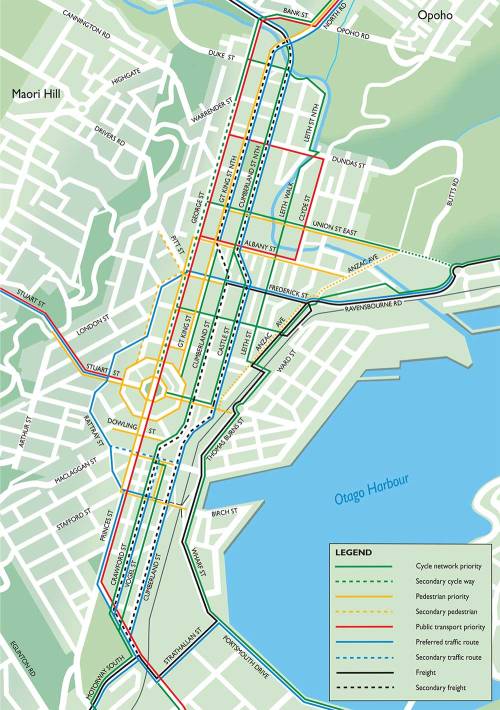
The Network Operating Plan (fig. 24) has been kept quiet by the DCC and the ODT. The plan is to make a big chunk of the CBD either car-less or mostly car-less. The methods of hindering motor vehicles haven’t been described but will be achieved with total bans from some streets as well as removing parking and restrictions on turning and entry. Another plan is to fiddle with the timing of traffic lights so as to cause intolerable delays to motorists. Have a look to see which streets are affected. While in their vision they see hoards of cyclists and pedestrians, more likely the CBD will become empty and turned into an economic dead-zone. The Network Operating Plan and the rest of the Transport Strategy are among the biggest threats that Dunedin faces.

Developing a Network Operating Plan [DCC]

Figure 24. Draft Network Operating Plan for the central cityFigure 24. Draft Network Operating Plan for the central city

Email received.
Tuesday, September 03, 2013 11:05 PM

—— Forwarded Message
From: Lee Vandervis
Date: Sun, 01 Sep 2013 09:06:00 +1200
To: Wendy Collard, Sarah Connolly, Emerson Yeoman, Sue Bidrose, Sandy Graham, Paul Orders
Cc: Kate Wilson, Andrew Noone, Jinty MacTavish, Teresa Stevenson
Conversation: Draft Transport Strategy Hearing additional data requested.
Subject: Re: Draft Transport Strategy Hearing additional data requested.

Ta Wendy,

Questions as follows:

Can I see Data to justify claims of:

1 – significant car ownership increase in the last 15 years/many Dunedin households now do not have access to a car. [A graph would be ideal]
2 – reduced fatalities and serious accidents [increasing safety] when transferring from automobile to pedestrian and cycling modes of transport [Elvik’s opinion on safety in numbers is not data and suggests only possibility with very large numbers of transfer not possible in a hilly city]
3 – increasing fossil fuel prices since 1974 “rising fuel costs” “Rising fuel prices are likely to lead to changes not only in travel behaviour and people’s choice of transport mode” “Assumption 1: The cost of fuel will continue to increase”
4 – increasing fuel efficiency of cars since 1974
5 – “much of car travel in Dunedin [or anywhere else] is non-essential”
6 – “other options are available for most trips”
7 – “deaths/serious injury of vulnerable road users [cyclists pedestrians] around schools” and “Safety problems at the school gate” “The research highlights that the transitory nature of traffic around schools has tended to hide the risks this situation presents to all users, but especially to children.”
8 – “poor provision for other modes and little congestion has led to high crash rates”
9 – “In part due to wide, high-speed urban street environments (such as the one-way system, Andersons Bay Road, Princes Street, and Hillside Road) and poor provision for other modes (such as buses, walking and cycling), road safety has suffered in Dunedin”
10 – “provision for private motor vehicles has also meant amenity, pedestrian connectivity and, in some instances, surrounding land use value has suffered”
11 – “Demand for cheap, convenient, and consistent on and off-street parking availability is no longer a realistic expectation with Dunedin’s modern high level of car use”
12 – “despite the fact that many children would prefer to cycle, scooter or walk to school”
13 – “it appears the cost of transport fuel will continue to rise for the foreseeable future. This is already having an effect on the way people are choosing to travel.”?

If reliable supporting data is not available, then these unsubstantiated claims and resultant aim to spend $47 million on cycling infrastructure should be removed from the Draft.

Kind regards,
Lee

——————————–

On 30/08/13 5:44 PM, “Wendy Collard” wrote:

Hi Lee

The deliberations have now finished. Kate has asked if you could please have the questions that you require to be answered be [sic] to staff by 12 noon on Sunday.

The hearing is going to carry on at 1pm on Monday as Public Forum has now been cancelled.

Regards

Wendy Collard
Governance Support Officer
Dunedin City Council
50 The Octagon, Dunedin; PO Box 5045, Moray Place, Dunedin 9058, New Zealand
Telephone: 03 474 3374, Fax: 03 474 3594

Related Posts and Comments:
30.8.13 Transport Strategy: Is this responsible local government?
29.8.13 The Don, imagines . . .
4.8.13 World War I memorial project
24.11.11 Dunedin buses: ORC or DCC
8.7.13 Bloody $tupid cycleways and Cull’s electioneering . . .
28.3.13 DCC Draft Annual Plan 2013/14: Portobello Harington Point…
8.3.13 Stupid bid for two-way highway ditched for now #DCC

Posted by Elizabeth Kerr

239 Comments

Filed under Business, DCC, Democracy, Design, Economics, Geography, Hot air, Media, Name, New Zealand, ORC, People, Politics, Project management, Property, Site, Stadiums, Tourism, Town planning, University of Otago, Urban design, What stadium

SH88 realignment: decision to Environment Court?

Updated Post 3.9.13 at 1:30pm

SH88 realignment [ODT Graphic]### ODT Online Mon, 2 Sep 2013
Decision on SH88 looms
By Debbie Porteous
The Dunedin City Council has until Friday to determine whether it will make a decision on the controversial designation of land for the realignment of State Highway 88 near Dunedin’s Forsyth Barr Stadium – or hand the responsibility for the decision to the Environment Court.
To opt for the latter would be a first for the council, which is both the authority requesting the land be designated, and the authority that would require it to be designated. It publicly notified the requirement for the land last month, after a previous non-notified designation was quashed by the court following the council’s admission it had not followed the proper consultation process. The new road has been built, but final measures including traffic lights have been in limbo while the designation issue is resolved.

Mr Hall has already indicated publicly he would ”fight” the proposed designation as notified because it still did not provide safe access to his property.

Doug Hall 1One of the affected landowners, Doug Hall, who is running for the DCC, took the council to court to argue the original designation was illegal because he was not notified as an affected party, and sought an injunction stopping the traffic lights from being switched on until the resolution of safety issues at that intersection and around access to his property as a result of the realigned road. Affected parties, including Mr Hall, were consulted on the new designation late last year, and again earlier this year after the notification of the requirement was delayed while negotiations with Mr Hall continued.
The council had received 13 submissions by Friday, the end of the submission period. Submitters included the University of Otago, Port Otago Ltd, the NZ Transport Agency, the Otago Regional Council and several heavy transport companies among others, but not Mr Hall, or his representatives.
Read more

ODT Correction 3.9.13 (page 3):

Submissions from companies owned by Doug Hall, one of the parties affected by the realignment of State Highway 88 in Dunedin, were received by the Dunedin City Council within the statutory timeframe and will be included in the process for designating the land for realignment. The submissions from Anzide Properties Ltd, Hall Brothers Transport Ltd, and Dunedin Crane Hire (2005) Ltd were received by deadline on Friday, but were not processed until yesterday.

Related Posts and Comments:
3.8.13 SH88 notice of requirement [more maps]
30.4.13 DCC governance = management ?
20.11.12 DCC vs Anzide Properties decision: The road “has no legal basis”
27.5.12 SH88 realignment – information
25.5.12 SH88 realignment costs (injunction)
27.2.12 Bringing DCC, related entities and individuals to account…
23.8.11 Stadium project tangles
4.11.10 SH88 realignment for stadium disrupts traffic
21.7.10 SH88 realignment – update
7.7.10 Goodbye to great store buildings in Parry St
21.4.10 SH88 realignment – update
31.3.10 SH88 realignment
24.2.10 SH88 realignment: Are ratepayers buying the land twice?
20.11.09 Interesting. SH88 realignment.
2.9.09 SH88 realignment past stadium

Posted by Elizabeth Kerr

45 Comments

Filed under Business, Construction, CST, DCC, Democracy, Design, Economics, Geography, Media, Name, New Zealand, People, Pics, Politics, Project management, Property, Site, Sport, Stadiums, Town planning, Urban design, What stadium

Transport Strategy: Is this responsible local government?

DRAFT Dunedin City Transport Strategy (2013)

The Otago Chamber of Commerce (COC) gets brownie points for taking a stick to Dunedin City Council and the politicised ‘sustainability crew’, this week… A crew primed with council staff, (spuriously-appointed) leadership and steering groups, university academics (with their little students in tow, aww) receiving substantial research funds into energy research, and the like; but let’s not forget the undue influence of Greater Dunedin and its two councillors, MacTavish and Wilson (paid $250 a day, was it?), sitting on the strategy panel – who, having spruced up their images lately (cutesy dyed haircuts, necklaces and dresses in adornment – closely resembling the old ‘pearl and cardy set’), will find the clobber just too awkward for bike riding.

It’s recognised the Chamber can’t hope to represent the wide breadth of Dunedinites – but it’s fair to say the Chamber’s focus and agendas (collectively and personally) are experienced as being unbearably narrow at times and slant at others – for example, its handling of the Dunedin harbourside plan change appeal, and its support for the new stadium (knife to the throat of Dunedin’s economy) and the proposed apartment and hotel development at 41 Wharf Street (cheap bling, with strings). All up, the Chamber is a mysterious if not loose male-order assembly of ‘business minds’.

Nevertheless, DCC, give your dog a bone…
But don’t think the Chamber will accept more stupidity from your transportation planners and general managers controlling the whole (desktop) strategic exercise —or from the ‘mission’ of idealistic ‘non-business’ greenies who lack the commonsense, experience, resilience and determination of Dunedin companies (the ones who actually make the dollars happen!), and which greenies will surely fail if pitted hard against Otago’s most successful export earners!!

The Transport Strategy is not a statutory document – but where it attempts to flow into District Plan changes, well, let’s wait for all the costly appeals to Environment Court. The council can hardly afford more legal battles – it can’t fund the challenges it’s already immured by.

The worst fear with the transport strategy revolves around pending changes to the Resource Management Act (RMA) which could see council-driven and developer-driven projects bulldozed through without public consultation; with few benefits to anyone or the environment, except to the proponents. The new legislation will mean even less accountability and transparency in local government than ever before – thanks to the National-led government. You know who to vote for in 2014.

Do you know who to vote for in 2013?

### ODT Online Fri, 30 Aug 2013
Attack on transport strategy
By Chris Morris
The Otago Chamber of Commerce has launched an attack on Dunedin’s draft transport strategy, saying it pushed a ”questionable agenda” of sustainability while ignoring major transport issues. The strongly-worded rebuke came in the chamber’s submission on the Dunedin City Council’s draft strategy, presented on the first day of a two-day public hearing yesterday.
However, Prof Herbert Harris, a member of the chamber’s logistics committee, also offered an olive branch at the hearing by suggesting a joint working party be formed to fix the document’s flaws.

Prof Harris said the strategy was of ”major concern” because it ignored the inadequate arterial route through the city, a lack of commuter parking and the significance of the road link to Port Otago.

The draft strategy sought to identify and address key transport challenges facing the city over the next 30 years, beginning with improving the city’s poor road safety record. Initiatives proposed included everything from a multimillion-dollar central-city upgrade, to improved cycleways, bus services and a new eastern freight bypass. Prof Harris said the strategy was of ”major concern” because it ignored the inadequate arterial route through the city, a lack of commuter parking and the significance of the road link to Port Otago.
Read more

Draft Dunedin City Transport Strategy 2013 (1)GREY AREAS… If you received this DRAFT Summary by post in late July, look no further than the grey back cover – it’s easier to read than the illegible and contrived contents, having about the same informational content.

****

### ODT Online Fri, 30 Aug 2013
Transport transfer considered
By Chris Morris
The Otago Regional Council says it will consider handing responsibility for public transport to the Dunedin City Council.
Council transportation planning manager Sarah Connolly confirmed a report on the issue was being finalised, and the chief executives of both organisations, Paul Orders and Peter Bodeker, would be briefed within weeks. Councillors from both organisations were yet to see the report, but a decision on how to proceed would be decided after the briefing, she said.
The news came two years after the Otago Daily Times reported the DCC and ORC were in talks about a possible transfer of the public transport network to the city council.
Read more

Related Posts and Comments:
29.8.13 The Don, imagines . . .
4.8.13 World War I memorial project
24.11.11 Dunedin buses: ORC or DCC
8.7.13 Bloody $tupid cycleways and Cull’s electioneering . . .
28.3.13 DCC Draft Annual Plan 2013/14: Portobello Harington Point…
8.3.13 Stupid bid for two-way highway ditched for now #DCC

Posted by Elizabeth Kerr

60 Comments

Filed under Business, Construction, DCC, Democracy, Design, Economics, Geography, Heritage, Hot air, Media, Name, New Zealand, ORC, People, Pics, Politics, Project management, Property, Site, Tourism, Town planning, University of Otago, Urban design

Archaeological site: Castle Street

### ch9.co.nz August 8, 2013 – 6:58pm
Slice of history comes to light
A slice of Dunedin’s past came to surface today outside the city’s historic railway station.
Video

Castle Street 1Castle Street 2Castle Street 3Castle Street 4Ch39 – nineteenth century footpath edging or water channel unearthed in Castle Street [screenshots]

Posted by Elizabeth Kerr

4 Comments

Filed under Heritage, Media, New Zealand, NZHPT, Pics, Property, Site

SH88 notice of requirement

DIS-2013-1 Location Map 1

DIS-2013-1 Fredrick St - Ravensbourne Rd (detail)Affected Party: Anzide Properties Ltd

Doug Hall, who was informed about the designation process on Thursday, said he was going to fight the issue. ”I have no choice. It is a safety issue. Someone is going to get killed on that road.”

### ODT Online Sat, 3 Aug 2013
Hall to oppose designation
By Hamish McNeilly
Dunedin businessman Doug Hall remains defiant after the Dunedin City Council confirmed it was revisiting the designation process for an affected area of State Highway 88. Yesterday, the council announced it had lodged a notice of requirement to restart the designation process, after negotiations stalled following a botched handling of the original process.
DCC general manager infrastructure and networks Tony Avery said the section of road had not been legally designated and the council acknowledged it had made process mistakes when trying to designate it earlier.
Last year, the Otago Daily Times reported the council had spent $485,000 over 18 months to try to find a solution, and it was too early to say how much the designation process would add to the final tally.
Read more

● Submissions on the notice of requirement, which is publicly notified today, close on August 30.

Dunedin City Council – Media Release
Designation Process for Part of State Highway 88

This item was published on 02 Aug 2013.

The Dunedin City Council has lodged a Notice of Requirement to start afresh the designation process for the section of State Highway 88 near Anzac Avenue.
The Notice of Requirement is a formal process to have land designated as road. It will be publicly notified tomorrow.
DCC General Manager Infrastructure and Networks Tony Avery says the new section of SH88 has been in use since July 2011, but has not been legally designated. The DCC has previously acknowledged that it made process mistakes during an earlier attempt to designate the road.
Temporary traffic controls have been in place since the new section of road was opened, while the DCC negotiated with an adjacent landowner over access arrangements.
“Those negotiations were ultimately unsuccessful, despite the best intentions of all parties, so we are now proceeding with the formal legal process to have the road designated.”
Once the designation proposed is approved, traffic lights at the intersection of Anzac Avenue and Frederick Street would be activated, and the Ward Street bridge ramp would be re-opened to provide much-needed access to the Harbourside area, Mr Avery says. Access to the adjacent properties is to be provided as well, consistent with acceptable standards and in a safe manner.
The DCC is confident the changes are in the best interests of the public.
Submissions on the Notice of Requirement will close on 30 August.

Contact General Manager Infrastructure and Networks on 477 4000.
DCC Link

DIS-2013-1 Layout PlanDIS-2013-1 Fredrick St – Ravensbourne Rd Layout Plan

Territorial Authority’s Requirement for Two Designations
DIS-2013-1 Fredrick Street – Ravensbourne Road

The requirement is for:
The Notice of Requirement seeks to designate two areas of land. Designation 1 is for part of the Dunedin Harbourside Arterial and will link Anzac Avenue (D465) with Ravensbourne Road (D845) to the south of Parry Street West. Designation 2 is for the Dunedin Harbourside Arterial – Access Road which will provide access from the Designation 1 area to the site at 80 Anzac Avenue.
Read more + Official Documents/Maps

### stuff.co.nz Last updated 18:04 20/11/2012
Dunedin City Council fined for road botch up
By Wilma McCorkindale – DScene
A High Court decision has slammed Dunedin City Council’s (DCC) handling of a roading realignment in the city, ordering the cash -strapped authority to pay affected parties more than $185,000 in costs. Justice Alan Mackenzie indicated in a written decision the legality of the stretch of State Highways 1 and 88 through the city remained in question because of the council’s botch up.
Read more

Judgment-221310 (PDF, 109 KB)

Related Post and Comments:
30.4.13 DCC governance = management ?
20.11.12 DCC vs Anzide Properties decision: The road “has no legal basis”
27.5.12 SH88 realignment – information
25.5.12 SH88 realignment costs (injunction)
27.2.12 Bringing DCC, related entities and individuals to account…
23.8.11 Stadium project tangles
4.11.10 SH88 realignment for stadium disrupts traffic
21.7.10 SH88 realignment – update
7.7.10 Goodbye to great store buildings in Parry St
21.4.10 SH88 realignment – update
31.3.10 SH88 realignment
24.2.10 SH88 realignment: Are ratepayers buying the land twice?
20.11.09 Interesting. SH88 realignment.
2.9.09 SH88 realignment past stadium

Posted by Elizabeth Kerr

Leave a comment

Filed under Business, Construction, CST, DCC, Democracy, Design, Economics, Media, Name, People, Politics, Project management, Property, Site, Stadiums, Town planning, Urban design

Portobello Road Consultation —Public Meeting | Monday 13 May

Portobellomeeting copy

Here is the latest web update for the Portobello Community.

This week we look at the road widening project and the proposed changes that the City Council has made to the initial plan. The City Council will be giving the community another opportunity to have your say on the proposal and the changes they have made to the plan since the consultation period in March 2013. This is an important issue for our township and community and the meeting is to be held at 7:00 pm on Monday, 13 May 2013 at the Coronation Hall. Pass this message onto your friends, neighbours, colleagues and whanau.

Regards
Paul Pope – Chairman, Portobello Incorporated

● The meeting will be attended by council staff, Cr Jinty MacTavish, and Otago Peninsula Community Board members.

Related Post and Comments:
28.3.13 | Updated 29.3.13
DCC Draft Annual Plan 2013/14: Portobello Harington Point Road Improvements Project

Posted by Elizabeth Kerr

9 Comments

Filed under Business, Construction, DCC, Design, Economics, Geography, Heritage, Name, Politics, Project management, Property, Site, Tourism, Urban design

DCC Draft Annual Plan 2013/14: Portobello Harington Point Road Improvements Project

Updated Post 29.3.13

Received yesterday by email.

Something that seems to have slipped the radar in Dunedin news of late is the WIDENING of Portobello Harington Point Road on the Otago Peninsula.

Looking at the Draft Annual Plan, the City Council intends to spend the following on what amounts to an environmental and heritage damaging folly. That’s only 33-34 % of the budget, given NZTA will subsidise the remaining 66-67% of the project.

DCC Draft Annual Plan - Road widening[click on image to enlarge]

See page 24, Section 1 Group of Activities (PDF, 1.5 MB)
and page 142, Section 2 Financial Statements (PDF, 1.2 MB)

The road widening (including the Vauxhall and Macandrew Bay areas already completed) will reclaim nearly 11 hectares of the Otago Harbour — a conservative measurement given plans show significantly more reclamation if the topography requires it.

Consultation on the current design closed yesterday, Thursday 28 March, indicating approval of the plan is a given despite the consultation process for the Annual Plan this year and in years to come.

[29.3.13 – The plans are not available for viewing online, why not?]

There will be irrevocable damage to the Peninsula and Harbour landscape, heritage features and the ecology if this misguided piece of engineering continues.

It is feared the Council has the bit between its teeth on this project — described as being about “liveability”, according to Mayor Cull at the Portobello Annual Plan ‘roadshow’.

It might be worth pointing out to your readers that they look closely at the Draft Annual Plan in regards to this area of Council expenditure.

Searching Council for cost benefit and recreational analyses fails to show much other than what is in the June 2008 Cycle Strategy (PDF, 787 KB).

[See also: Dunedin’s Proposed Cycle Network, adopted August 2011]

Few will have problems with the desirability of access, but the lack of design sensitivity and impact on the values of the area seem inconsistent with the value of the Peninsula and Harbour to the community and our economy.

This is certainly an issue worth looking at more deeply.

[ends]

Posted by Elizabeth Kerr

14 Comments

Filed under Business, Construction, DCC, Design, Economics, Geography, Heritage, Politics, Project management, Site, Tourism

Dunedin City Council vs Anzide Properties decision: The road “has no legal basis”

Concerning the State Highway 88 realignment, skirting the new stadium.

Judgment-221310 (PDF, 109 KB)

DScene breaks the news at Stuff:

Dunedin City Council fined for road botch up
A High Court decision has slammed Dunedin City Council’s (DCC) handling of a roading realignment in the city, ordering the cash-strapped authority to pay affected parties more than $185,000 in costs. Justice Alan Mackenzie indicated in a written decision the legality of the stretch of State Highways 1 and 88 through the city remained in question because of the council’s botch up.

Related Posts:
9.6.12 City Property to compete more obviously in the market
27.5.12 SH88 realignment – information
25.5.12 SH88 realignment costs (injunction)
27.2.12 Bringing DCC councillors, staff, related entities and individuals to account
23.8.11 Stadium project tangles
24.11.10 SH88 realignment for stadium disrupts traffic
29.10.10 DCC Chief Executive resigns – timing is everything!
21.7.10 SH88 realignment – update
7.7.10 Goodbye to great store buildings in Parry St
21.4.10 SH88 realignment – update
31.3.10 SH88 realignment
24.2.10 SH88 realignment: Are ratepayers buying the land twice?
20.11.09 Interesting. SH88 realignment.
2.9.09 SH88 realignment past stadium
27.8.09 $294.8m investment for Otago region
19.5.09 There’s more, really?
12.2.09 DCC, and the right to ask?

Posted by Elizabeth Kerr

72 Comments

Filed under Business, Construction, DCC, Geography, People, Project management, Property, Site, Stadiums, Town planning, Urban design

SH88 realignment – information

Comment received from daseditor
Submitted on 2012/05/26 at 8:18 pm

[24.5.12] Edmund Anscombe and the Anzac Avenue Trees

With your discussion of the alignment I hope you’ll also take the time to read the article above on the Anzac Avenue trees. The alignment construction looks as though it has severely affected a critical area of the city’s landscape heritage which is linked to the work of prominent architect Edmund Anscombe.

Images supplied by Anonymous*

The image dates relate to Google Earth snapshots: 2005 January, 2006 March, 2009 July, 2011 January, and 2011 September. 2004 is available but heavy cloud cover obscures the view.

SH88 – Google Earth images including the quarry and Logan Park sports field.

SH88 – The same images cropped to SH88 entry and exit points.

SH88 – The Google Maps image which marks the road.

*Several contributors at this website use the title Anonymous.

Related Post with Links:
25.5.12 SH88 realignment costs (injunction)

Posted by Elizabeth Kerr

12 Comments

Filed under Construction, DCC, Design, Economics, Geography, Pics, Project management, Property, Site, Stadiums, Town planning, Urban design

Development contributions

### ODT Online Tue, 8 Nov 2011
Development debate
By David Loughrey

Development contributions are fees levelled on property developers to pay for infrastructure required by subdivisions, such as water and wastewater, roads and reserves. Under proposed changes, developments placing additional demand on infrastructure could attract extra charges.

The Dunedin City Council will sit on November 22 to consider what Mayor Dave Cull said was a complex issue – a charge on developers opponents say could kill development in Dunedin. The council yesterday ended a three-day hearing on the issue that raised a host of legal and philosophical questions, and highlighted many areas where more work needed to be done.
Read more

****

### ODT Online Tue, 8 Nov 2011
Heavyweight attack on plan
By David Loughrey

Lawyer Phil Page, for CIDA, Cranbrook Properties and Balmoral Investments, said there was a legal prohibition on “double dipping”, with the Forsyth Barr Stadium providing a good example. It was paid for through council company dividends, made up for by rates. It could not be charged for again through development contributions, something Mr Page said was “a key issue here”.

The group opposing a new charge on developers in Dunedin wheeled out its big guns yesterday, with a parade of lawyers, valuers, tax specialists, planners and builders to argue against the charge from every possible angle. The Construction Industry and Developers Association (CIDA), set up to oppose the draft development contributions policy, took up most of the third and final day of hearings on the issue.
Read more

Related Post:
23.3.11 Dunedin City Council’s rock and its hard place

Posted by Elizabeth Kerr

2 Comments

Filed under Architecture, Construction, DCC, Design, Economics, Geography, Politics, Project management, Site, Stadiums, Town planning, Urban design

“Transforming a sea of asphalt”

What was that down at Awatea Street. Ever get sick of petrochemical surfaces and glaring urban planning ineptitudes… And yes, DCC urban designers, I agree with you, public streets can be more than traffic corridors – the potential mixes or sequences of use are the opportunity…

Chris Doudney, retired University of Otago Staff Architect sent me this link, saying: “The comments run the full gamut of objection/support – I liked the heartfelt one from the waterfront champion.”

BY DESIGN
Allison Arieff – A New York Times Blog
September 22, 2009, 10:00 pm
Pavement to Parks

Last Friday, cities and towns throughout the world celebrated Park(ing) Day, an event created to bring awareness to the importance of using and enjoying public space. Witnessing all those swaths of pavement transformed into plant-filled community gathering spaces (Streetfilms.org has a short film of San Francisco’s Park(ing) Day) got me thinking about — given the tangential way my brain works — the process of land-banking.

Land banking — the strategic acquisition of land in advance of expanding urban development, and the holding on to it as long as possible to maximize profits — is especially pronounced in once-booming, now-busted city centers like Las Vegas, Baltimore and Phoenix, which by the way now has more vacant land than any other major city in the United States. With the economic downturn things have changed somewhat, but there remain huge numbers of empty lots being “banked” in downtowns nationwide, all waiting for a real estate recovery.
Read more

– Allison Arieff is editor at large for Sunset, and the former editor in chief of Dwell magazine. She is co-author of the books “Prefab” and “Trailer Travel”, and the editor of many books on design and popular culture, including “Airstream: The History of the Land Yacht” and “Cheap Hotels”. Allison Arieff lives in San Francisco.

Post by Elizabeth Kerr

1 Comment

Filed under Architecture, Design, Economics, Events, Fun, Inspiration, Site, Town planning