Tag Archives: Seawall

Dunedin: Erosion issues at St Clair and Ocean Beach

Received from Paul Pope
Fri, 25 Mar 2016 at 3:01 p.m.

█ Message: I filmed this short video the other day and spliced in some information on how the erosion at St Clair actually happens. I don’t often use video, but it looks very compelling. I put it into the Beginners Guide to Coastal Conservation on Facebook yesterday and it’s had more than 7000 views, so people are interested in what’s going on.

[view full screen]
Paul Pope Published on Mar 24, 2016
The Physics of Erosion
The erosion issues at St Clair Beach and the whole of Ocean Beach in Dunedin have become more and more serious in recent years. Understanding the reasons behind what people see at St Clair is very important. The community need to be able to make informed decisions about these damaging processes.

Related Posts and Comments:
● 11.9.15 RAPID dune erosion continues —Council doesn’t give a toss
● 19.8.15 Paul Pope’s strategic overview of coastal conservation #Dunedin
● 11.8.15 DCC’s unmanaged retreat for South Dunedin
● 22.7.15 DCC Long Term Plan 2015/16 – 2024/25
10.4.15 DCC: Natural Hazards
28.3.15 DCC Draft Long Term Plan 2015/16 to 2024/25 —Consultation Open
23.11.13 DCC: St Clair esplanade and seawall [public forum] 27 November
18.10.13 DCC: Final vote tally + St Clair boat ramp
18.8.13 South Dunedin and other low lying areas
26.5.13 [bad news] St Clair seawall #FAIL
10.9.12 John Wilson Ocean Drive … reminder to all of DCC incompetence
30.7.12 ORC on hazard risks and land use controls
28.11.11 St Clair seawall and beach access

█ For more, enter the term *coastal* in the search box at right.

Posted by Elizabeth Kerr

17 Comments

Filed under Business, Construction, DCC, Democracy, Design, District Plan, Dunedin, Economics, Geography, Heritage, Infrastructure, Leading edge, Media, Name, New Zealand, People, Politics, Project management, Property, Proposed 2GP, Resource management, Site, South Dunedin, Structural engineering, Tourism, Town planning, Travesty, Urban design, What stadium

RAPID dune erosion continues —Council doesn’t give a toss

Dunedin esplanade St Clair [infonews.co.nz]Coastal Feb 2015 [world50th.files.wordpress.com]

Alex Gilks replies to article St Clair dunes ‘in no danger’ (ODT 3.9.15)

Published at ODT Online
Wed, 9 Sep 2015

Your say: Urgent action is needed
By Alex Gilks
Wayne Stephenson’s comments here, assuming they were reported accurately, seem quite a way off the mark. I’m no expert, but grew up near the dunes, and walk on the beach often.
I visited this morning, and the big sea earlier this week has carved off more of the top of the dune. The two big pines are about 5m and 10m from the edge of the erosion. Bill Brown is right: urgent action is needed. Big-scale protection at the bottom.
Putting aside the throwaway comment about the asteroid, here are the troubling things about this article:

• ‘no risk to property this year’ – this super short-term thinking should be criticized

• ‘if the dune’s foot was staying in place’ – the dune’s foot is absolutely not staying in place! The immediate reason for the dramatic erosion is that the toe of the dune has been completely hammered since the sand sausages were ruined. How can he not see that? Is he not actually visiting the site?

• the idea that the enemy is ‘winter’s storms’, and the implication that it will be ok again until next winter. Where does this come from? The south coast can get powerful southerlies at any time of year. Is there some data that you can use to show the frequency and time of year of southerly/easterly storms and high tides?

• sand sausages and sand replenishment as interim solutions, before ‘more permanent features in coming years’. Shouldn’t this receive more criticism? The previous sands sausages and sand replenishment worked for only what, a handful of years? Wouldn’t you just urgently undertake some more long-term solution?

For this to get real I think decision-makers need to walk along the ridge track from the Kettle Park area, see the shifting edge and the remaining area at the apex of the dune.
I’d take a botanist along too, to get a good gauge on the age of the trees that have been uprooted. The bigger ones must be 50-80 years old, yet you hear some people saying things like ‘this happened in the 70s/90s/a few years back’.
No. We need to get past this complacent idea that this is a seasonal thing, that it’ll replenish itself soon and will start working normally again in the near future.
ODT Link

Received from Hype O’Thermia
Tue, 8 Sep 2015 at 10:36 a.m.

The sea does not adapt to humans

Increased storms and extreme weather – get off yer bike! Just for fun I googled “British houses that fell into the sea”, not a helluva rigorous search……..

One dark night in 1664, while local people were attending a wake, the whole village of Runswick slipped into the sea…
Thankfully, all the villagers escaped but by morning there was only one house left standing… the house of the dead man!
http://www.visitengland.com/experience/discover-village-fell-sea

As late as 1817 when George Young, the Whitby historian, wrote of the incident, articles including a silver spoon and coins which had been carried from the rubble by the tide were still being washed back.
http://www.chrisscottwilson.co.uk/runswick-bay/4551457861

It wasn’t always so peaceful – one night in 1664 the entire village slid into the sea! Returning from a wake, one of the villagers noticed the steps of his house slipping away beneath his feet. He gave the alarm and most of the village fled to safety. By morning only one house remained standing- the house of the deceased man. The village was rebuilt further around the shore but land slippage continued to be a problem. In 1970 a new sea wall was finally built, thankfully securing the village’s future.
http://www.simonseeks.com/travel-guides/hands-all-those-whove-heard-runswick-bay__167571

In medieval times, when Dunwich was first accorded representation in Parliament, it was a flourishing port and market town about thirty miles from Ipswich. However, by 1670 the sea had encroached upon the town, destroying the port and swallowing up all but a few houses so that nothing was left but a tiny village. The borough had once consisted of eight parishes, but all that was left was part of the parish of All Saints, Dunwich – which by 1831 had a population of 232, and only 44 houses (“and half a church”, as Oldfield recorded in 1816).
https://en.wikipedia.org/wiki/Dunwich_(UK_Parliament_constituency)

Robin Hood’s Bay, North Yorkshire
The raging storms have taken their toll, claiming many buildings as the limestone cliffs erode. In 1780, 22 cottages fell into the sea. Today a rock seawall helps protect the picturesque village.
http://www.britainexpress.com/villages/robinhood.htm

[ends]

Related Posts and Comments:
● 19.8.15 Paul Pope’s strategic overview of coastal conservation #Dunedin
● 11.8.15 DCC’s unmanaged retreat for South Dunedin
● 22.7.15 DCC Long Term Plan 2015/16 – 2024/25
10.4.15 DCC: Natural Hazards
28.3.15 DCC Draft Long Term Plan 2015/16 to 2024/25 —Consultation Open
23.11.13 DCC: St Clair esplanade and seawall [public forum] 27 November
18.10.13 DCC: Final vote tally + St Clair boat ramp
18.8.13 South Dunedin and other low lying areas
26.5.13 [bad news] St Clair seawall #FAIL
10.9.12 John Wilson Ocean Drive … reminder to all of DCC incompetence
30.7.12 ORC on hazard risks and land use controls
28.11.11 St Clair seawall and beach access

█ For more, enter the term *coastal* in the search box at right.

Posted by Elizabeth Kerr

*Images: dunedinisforlovers.blogspot.co.nz – Majestic Mansions (April 2010); world50th.files.wordpress.com – dunes (February 2015)

7 Comments

Filed under Business, Construction, DCC, Democracy, Design, Economics, Geography, Heritage, Media, Name, New Zealand, ORC, People, Politics, Project management, Property, Site, Sport, Tourism, Town planning, What stadium

Paul Pope’s strategic overview of coastal conservation #Dunedin

Received from Paul Pope
Wed, 19 Aug 2015 at 10:52 a.m.

█ Message: I see sand dunes and erosion are a hot topic on the What if? website. I thought I would send you a submission I made to the City Council on Ocean Beach Domain in 2008/2009 which gives a detailed strategic overview of coastal issues and provides a basis for a variety of solutions to a number of problems including land occupation. Also I have created a Facebook page under my personal account called: The beginners guide to coastal conservation.
I created it to provide people with information on coastal issues.

[screenshot]

Ocean Beach Domain Submission Doc [718853] by Paul Pope [cover contents]

█ Download: Paul Pope: Ocean Beach Domain Submission (PDF, 1 MB)

Related Post and Comments:
● 11.8.15 DCC’s unmanaged retreat for South Dunedin
● 22.7.15 DCC Long Term Plan 2015/16 – 2024/25
18.7.15 DCC Cycleways: SEEING RED, apology NOT accepted
14.7.15 DCC strategies needed like a hole in the head
12.6.15 Fairfax: DCC has no insurance cover for flood-damaged roads
5.6.15 WEATHER is not climate change; this is not the 100-year flood
4.6.15 Exchange makeover —or pumps and pipe renewals, um
3.6.15 Civil Defence response to Dunedin FLOODING
10.4.15 DCC: Natural Hazards
28.3.15 DCC Draft Long Term Plan 2015/16 to 2024/25 —Consultation Open
14.10.14 ORC: New strategic plan fosters Otago prosperity
12.9.14 ORC: City bus services, submissions
10.12.13 ORC restructures directorates
23.11.13 DCC: St Clair esplanade and seawall [public forum] 27 November
18.10.13 DCC: Final vote tally + St Clair boat ramp
18.8.13 South Dunedin and other low lying areas
26.5.13 [bad news] St Clair seawall #FAIL
26.2.13 DCC binge spending alert: Proposed South Dunedin cycle network
10.9.12 John Wilson Ocean Drive … reminder to all of DCC incompetence
30.7.12 ORC on hazard risks and land use controls
7.6.12 Dunedin stormwater: more differences between ORC and DCC
28.11.11 St Clair seawall and beach access
25.11.11 South Dunedin and other flood zones
7.12.09 Coastal protection zones
14.11.09 From the log books of a twenty-year distress #DCC
24.8.09 1. STS response – appeal 2. Coastal protection – comments

Posted by Elizabeth Kerr

45 Comments

Filed under Business, Construction, Cycle network, DCC, Democracy, Design, Economics, Geography, Heritage, Inspiration, Name, New Zealand, People, Politics, Project management, Property, Site, Tourism, Town planning, Transportation, Urban design, What stadium

DCC’s unmanaged retreat for South Dunedin #naturalhazards

█ SOME BUILDINGS NOW JUST 12M FROM DUNE’S FACE

Bill Brown, who initially raised his concerns in the Otago Daily Times last month, feared no urgency had been shown by council staff since then.

Spring’s king tides were still to come and could bring dramatic further erosion, he said in his written submission.

### ODT Online Tue, 11 Aug 2015
Disappearing dunes ‘an immediate problem’
By Craig Borley
Dunes along Dunedin’s Ocean Beach have receded nearly 9m in the past four weeks and will continue to disappear unless immediate action is taken, a St Clair resident told the Dunedin City Council yesterday …. [Bill Brown] took those concerns to the council’s community and environment committee, where he presented several aerial photographs showing the extent of recent erosion.
Read more

ODT: ORC has role to play
Responsibility for erosion repairs at Dunedin’s Ocean Beach may not lie solely with the Dunedin City Council, its community and environment committee heard yesterday

ODT: Erosion problem for rugby club
The Dunedin Rugby Football Club has made no decision on where its future lies but its training lights have been out of use because of costal erosion and sand is encroaching on to its main ground.

### ODT Online Fri, 10 Jul 2015
Beach erosion: ‘For God’s sake, it’s time to take action’
By Craig Borley
Permanently fix the erosion of St Clair’s sand dunes or give up on most of South Dunedin – there are no other options, a St Clair resident believes. Heavy seas in the past month have washed out several metres of sand dunes.
Read more

St Clair Beach / Esplanade
St Clair Beach, Dunedin [wikimedia.org]St Clair Beach 2014, Dunedin - img_1711b [uniquelynz.com] 1(top) wikimedia.org – historical view | uniquelynz.com – 2014 view

### ODT Online
Sea wall plan ‘not about savings’
By Chris Morris on Mon, 24 Nov 2014
A squeeze on Dunedin City Council finances is not behind a push to defer multimillion-dollar options to protect the St Clair sea wall, Dunedin Mayor Dave Cull insists. A council staff report recommends any plans for major capital works – such as a groyne to protect the sea wall and properties behind it – be put on hold.
Read more

Managed retreat….

### ODT Online Thu, 23 Feb 2012
Engineer says let erosion take South Dunedin
By Chris Morris
Allowing coastal erosion to reclaim Kettle Park should be the start of a wider retreat from South Dunedin, a Dunedin City Council hearings committee has heard. The call came from Sustainable Dunedin City co-chairman Phillip Cole – a former civil engineer of 31 years’ experience – as the committee considered a second day of submissions on its draft management plan for Ocean Beach.
Read more

DCC Webmap – South Dunedin Jan/Feb 2013 [click to enlarge]
DCC Webmap - South Dunedin JanFeb 2013 1aDCC Webmap - South Dunedin JanFeb 2013 1b

DCC Natural Hazard Maps
Note: These maps are DRAFT only. The boundaries of hazard areas and hazard risk classification may be subject to change based on consultation feedback and further assessment ahead of notification. We strongly encourage feedback on any adjustments that may be required.
You also can use the interactive District plan map in the related information section, to see the current District Plan zoning, and the potential 2GP zoning, including the proposed hazard overlay zones, for your property

██ http://www.dunedin.govt.nz/whats-on/2gp/natural-hazards-phase/natural-hazard-maps

The maps identified “extreme risk” land in red, which some Dunedin homeowners had “instantly associated with red-zoning in Christchurch”. –Sally Dicey, DCC policy planner

### ODT Online Thu, 25 Sep 2014
Concerns raised over natural hazards plan
By Chris Morris
Homeowners worried about being left in a Christchurch-style red zone – at least on paper – are calling for changes to the Dunedin City Council’s natural hazards plan. Their concerns come as council staff wade through nearly 200 submissions received since the council’s plan to tighten its grip on some city properties, to better protect against natural hazards, was announced in June.
Read more

### ODT Online Mon, 12 Jan 2009
Council weighs costly Esplanade options
By Chris Morris
The Dunedin City Council is weighing several “quite expensive” options aimed at preventing improvements to the Esplanade, at St Clair, crumbling in the next big storm. Parts of the Esplanade upgrade, which has so far cost more than $6 million, have had repeated structural problems since being largely completed in 2004.
Read more

### ODT Online Fri, 19 Sep 2014
ODT: 100 Years Ago
St Clair to St Kilda esplanade proposed –ODT, 19.9.1914
The Amenities Committee of the Dunedin Expansion League is displaying a laudable energy in urging upon the Ocean Beach Domain Board the desirability of adopting a scheme for the construction of an esplanade along the sea-front from St Clair to St Kilda. Plans have been secured from the city engineer, and the Committee has fortified itself by obtaining a report upon Mr McCurdie’s proposals from the engineer of the Harbour Board, the advice of a marine engineer being justly considered to be of importance in connection with such an undertaking.
Read more

Related Posts and Comments:
10.4.15 DCC: Natural Hazards
10.12.13 ORC restructures directorates
23.11.13 DCC: St Clair esplanade and seawall [public forum] 27 November
18.10.13 DCC: Final vote tally + St Clair boat ramp
26.5.13 [bad news] St Clair seawall #FAIL
10.9.12 John Wilson Ocean Drive … reminder to all of DCC incompetence
30.7.12 ORC on hazard risks and land use controls
28.11.11 St Clair seawall and beach access
7.12.09 Coastal protection zones
14.11.09 From the log books of a twenty-year distress #DCC
24.8.09 1. STS response – appeal 2. Coastal protection – comments

Posted by Elizabeth Kerr

50 Comments

Filed under Business, Construction, DCC, Democracy, Design, Economics, Geography, Heritage, Media, Name, New Zealand, ORC, People, Pics, Politics, Project management, Property, Site, Sport, Town planning, Urban design, What stadium

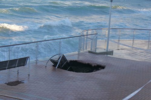
Sinkhole

Friday, 31 May 2013 4:34 p.m.

St Clair Esplanande 31.5.13 (1)St Clair esplanade, Dunedin [image supplied – click to view enlarged]

Related Posts and Comments:
26.5.13 [bad news] St Clair seawall #FAIL
28.11.11 St Clair seawall and beach access
31.3.11 St Clair esplanade, Dunedin

Posted by Elizabeth Kerr

12 Comments

Filed under Construction, DCC, Design, Economics, Geography, Pics, Project management, Property, Site, Urban design

Carisbrook and Leith flood protection

Received from Rob Hamlin.
Monday, 27 May 2013 1:03 p.m.

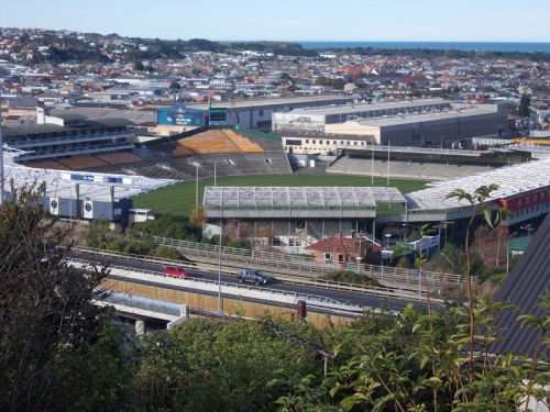
Carisbrook on Sunday (26.5.13)

Carisbrook 26.5.13. Rob Hamlin 1
A picture of doomed dereliction – Innit? I tried to take photos of this last week, but the weather wasn’t good enough. I seem to recall that the comb lines in the manicured grass were going in a different direction then, indicating that further ratepayer-funded pampering has occurred this last week. What earthly reason can there be for the DCC to be spending money doing this on a structure that they claim they have a) sold and b) issued a demo permit for? Some seats are missing (but could be inside). The lights are gone, but Delta bought the last set anyway so why not ‘play it again Sam’?

Otago Regional Council – Leith Flood Protection Scheme

Water of Leith 001 (1)001 ‘Sad Sacking’
The results of the equally seawall-like doomed attempts by the ORC and their representatives to establish a million dollar[?] lawn in the middle of winter in the bottom of a drainage channel occupied by a major flood prone waterway (the Leith). An act of simply heroic lunacy. This is the aftermath of the minor flood last week. The proto-lawn is covered in sacking further up the river, except for the bit next to the water – that’s now wrapped around the post in the foreground. Luckily it did not end up in the harbour – although many tons of silt presumably did. No doubt the ORC will be able to issue itself with a retrospective resource consent for this uncontrolled discharge into the environment.

Water of Leith 002 (1)Water of Leith 004 (1)002, 004 ‘Washed away’
For weeks now and presumably at great expense to the ORC, the contractors (Lund if the site signs are to be believed) have been laying down what looks like micropore mat, hexagon reinforcement, and what looks like a very expensive chicken wire plastic mesh combo – stitched together. They then planted grass on it. This can be seen growing feebly on the slope in 002. Alas, the minor flood that dislodged the sacking also gently sluiced out the soil and grass from the expensively-laid reinforcements on the level parts of the lawn laid (lunacy) right up to the edge of the river.

Water of Leith. Robert Hamlin (1)000 gives a higher angle shot showing the artistry of this now exposed and empty (of soil) soil stabilisation system, along with the feeble grass above it. I am not sure how they will reposition the soil into this stuff short of ripping it up and starting again. Presumably if all this expensive stuff was intended to stop soil coming out, it will be equally good at resisting attempts to put it back in again by mechanical means. Oh dear!

Water of Leith 003 (1)003 ‘Mighty defences’
Here we have what is actually supposed to keep the Leith in the straight and narrow from now on. This is the concrete shuttering for an incomplete part of the bank (this shuttering is now filled with shyte from the flood). The wall when poured (one hopes after clearing out said shyte) will be a worthy successor to the St Clair seawall – it is about 12 inches tall and 8 inches thick. It is plastered onto the top of (rather than onto the front of as with the seawall) the remains of its more substantial predecessor. The lawn (in the areas where it used to be there) starts directly behind it…

Water of Leith 005 (1)005 ‘Classy concrete placing’
The mighty foot-high defences take an interesting course in the photograph taken looking up the left-hand bank from the Forth Street Bridge. I do not know if this feature-bulge in the mighty wall is the outcome of a molar-like architectural design feature to increase the organic appearance of the site or if it’s simply a concrete shuttering quality control issue. It’s your rates money – you decide.

Posted by Elizabeth Kerr

*Photos: Rob Hamlin (May 2013)

7 Comments

Filed under Construction, DCC, Design, Economics, ORC, People, Pics, Project management, Property, Site, Sport, Stadiums, Urban design

[bad news] St Clair seawall #FAIL

Comment received from Stu.
2013/05/26 at 7:29 pm

St Clair sea wall compromised? Webcam image refreshes every 1 minute.

http://media.wickednetworks.co.nz/current-stclair.jpg

Tweet to @whatifdunedin from @lowercasewriter.

Tweet @lowercasewriter 26.5.13

StClair

Related Post and Comments:
28.11.11 St Clair seawall and beach access

Posted by Elizabeth Kerr

140 Comments

Filed under Construction, DCC, Design, IPENZ, Project management, Property, Site, Urban design

St Clair seawall and beach access

### ODT Online Mon, 28 Nov 2011
Future of damaged beach ramp to be assessed
By David Loughrey
A section of a St Clair beach ramp in Dunedin might soon be removed, after it broke away and fell on to rocks below. The problem is a continuation of damage that occurred about six weeks ago, when heavy seas hit the ramp so hard the concrete cracked, and steel reinforcing was exposed.
Read more + Images

ODT Video: Big surf at St Clair

Posted by Elizabeth Kerr

54 Comments

Filed under Construction, DCC, Design, Economics, Politics, Project management, Site, Urban design